335 Best Sights in Israel

Achziv Beach

Fodor's choice

This beautifully maintained stretch of sand in the Achziv National Park is north of Nahariya, on the road to Rosh Hanikra. Beside the ruins of the ancient settlement of Achziv are two huge lagoons along the shore, one shallow, the other deep. There are also watchful lifeguards and playground facilities. In July and August, turtles lay their eggs on the beach. You can picnic on the grassy slopes or make use of the restaurant. Enter at the second sign for Achziv Beach, not the first. For NIS 63 per person, you can camp here overnight. Amenities: food and drink; lifeguards; parking (fee); showers; toilets. Best for: swimming; walking.

Al-Jazzar Mosque

Fodor's choice

This house of worship, the largest mosque in the country outside of Jerusalem, is also considered one of the most beautiful in Israel. Ahmed el-Jazzar, who succeeded Dahr el-Omar after having him assassinated, ruled Akko from 1775 to 1804. During his reign he built this mosque along with other public structures. His cruelty was so legendary that he earned the epithet "the Butcher." (He is buried next to his adopted son in a small white building to the right of the mosque.)

Just beyond the entrance is a pedestal engraved with graceful calligraphy; it re-creates the seal of a 19th-century Ottoman sultan. Some of the marble and granite columns in the mosque and courtyard were plundered from the ruins of Caesarea. In front is an ornate fountain used by the faithful for ritual washings of hands and feet before prayer. Inside the mosque, enshrined in the gallery reserved for women, is a reliquary containing a hair believed to be from the beard of the prophet Muhammad; it is removed only once a year, on the 27th day of Ramadan.

The mosque closes five times a day for prayers, so you might have a short wait. On Friday, the prayer duration is longer, as it is the holiest day of the week for Muslims. Although the mosque is open, visitors are advised to plan their trip accordingly. Dress modestly.

Off Al-Jazzar St., 24110, Israel
04-991–3039
Sights Details
Rate Includes: NIS 10

Avdat National Park

Fodor's choice

The hilltop remains of the Nabatean city of Avdat loom over part of the old Incense Route between Petra and Gaza, a reminder of how valuable incense, spices, and perfumes from Arabia were in ancient times. The Nabateans were seminomadic people who came here from northern Arabia in the 3rd century BC. With their prosperous caravan routes connecting the desert hinterland to the port city of Gaza, they soon rose to glory with a vast kingdom whose capital was Petra, in present-day Jordan. Strongholds to protect the caravans were established along these routes, usually a day's journey apart. Most of the remains on the acropolis date from the 3rd, 4th, and 5th centuries—the Christian Byzantine period. The city continued to flourish until it was sacked by the Persians in AD 620; it was rediscovered only in the 20th century.

Start at the visitor center, where you can learn about the Nabateans in a 10-minute video, see examples of what these ancient traders actually transported across the desert, and examine archaeological artifacts found in the excavations. Drive up the road (save your energy for walking around the site), stopping first at the sign for the Roman burial cave, which is well worth a quick peek. The 21 double catacombs cut into the rock date from the 3rd century BC.

Back in your car, drive up to the lookout point at the restored Roman building (note the watchtower with an inscription dating to the late 3rd century). The cultivated fields below were re-created in 1959 in order to see if the ancient Nabatean and Byzantine methods of conserving the meager rainfall would still work. The proof is in the lush greenery before you.

Using the Israel Nature and Parks Authority's excellent map, you can trace the lifestyle of the original inhabitants at sites that include a reconstructed three-story Roman tower, a rare Nabatean pottery workshop, a Byzantine-era winepress, two Byzantine churches, and a large baptismal font built to accommodate the converted. Near the baptismal font, you can walk down the steps to see 6th-century Byzantine dwellings, each consisting of a cave (possibly used as a wine cellar) behind a stone house. At the bottom of the hill, north of the gas station, is a Byzantine bathhouse. There is a rest area with food and drink near the visitor center.

Recommended Fodor's Video

Baha'i Shrine and Gardens

Fodor's choice

The most striking feature of the stunning gardens that form the centerpiece of Haifa is the Shrine of the Bab, whose brilliantly gilded dome dominates the city's skyline. The renovated shrine gleams magnificently with 11,790 gold-glazed porcelain tiles.

Haifa is the world center for the Baha'i faith, founded in Iran in the 19th century. It holds as its central belief the unity of mankind. Religious truth for Baha'is consists of progressive revelations of a universal faith. Thus the Baha'is teach that great prophets have appeared throughout history to reveal divine truths, among them Moses, Zoroaster, Buddha, Jesus, Muhammad, and most recently, the founder of the Baha'i faith, Mirza Husayn Ali, known as Baha'u'llah—“the Glory of God." The Shah and then the Ottomans exiled Baha'u'llah (1817–92) from his native Persia to Akko, where he lived as a prisoner for almost 25 years. The Baha'is holiest shrine is on the grounds of Baha'u'llah's home, where he lived after his release from prison and is now buried, just north of Akko.

Here in Haifa, at the center of the shrine's pristinely manicured set of 19 garden terraces, is the mausoleum built for the Bab (literally, the "Gate"), who heralded the coming of a new faith to be revealed by Baha'u'llah and who was martyred by the Persian authorities in 1850. Baha'u'llah's son and successor built the gardens and shrine and had the Bab's remains reburied here in 1909. The building, made of Italian stone and rising 128 feet, gracefully combines the canons of classical European architecture with elements of Eastern design and also houses the remains of Baha'u'llah's son. The dome glistens with some 12,000 gilded tiles imported from the Netherlands. Inside, the floor is covered with rich Asian carpets, and a filigree veils the serene inner shrine.

The magnificent gardens, with their gravel paths, groomed hedges, and 12,000 plant species, are a sight to behold: stunningly landscaped circular terraces extend from Yefe Nof Street for 1 km (½ mile) down the hillside to Ben Gurion Boulevard, at the German Colony. The terraces are a harmony of color and form—pale pink-and-gray-stone flights of stairs and carved urns overflowing with red geraniums set off the perfect cutouts of emerald green grass and floral borders, dark green trees, and wildflowers, with not a leaf out of place anywhere. The gardens, tended by 120 dedicated gardeners, are one of Israel's 11 UNESCO World Heritage Sites.

Three areas are open to the public year-round, except on Baha'i holidays: the shrine and surrounding gardens ( 80 Hatzionut Ave., near Shifra St.); the upper terrace and observation point ( Yefe Nof St.); and the entry at the lower terrace ( Hagefen Sq., at the end of Ben Gurion Blvd.). Free walk-in tours in English are given at noon every day except Wednesday. These depart from 45 Yefe Nof Street, near the top of the hill. Note: the Shrine of the Bab is a pilgrimage site for the worldwide Baha'i community; visitors to the shrine are asked to dress modestly (no shorts).

Basilica of the Annunciation

Fodor's choice

The Roman Catholic Basilica of the Annunciation, the largest church in the Middle East, was consecrated in 1969; it enshrines a small ancient cave dwelling or grotto, identified by many Catholics as the home of Mary. Here, they believe, the angel Gabriel appeared to her and announced she would conceive and "bear a son" and "call his name Jesus" (Luke 1). Pilgrim devotions suffuse the site throughout the day. Crusader-era walls and some restored Byzantine mosaics near the grotto bear witness to the antiquity of the tradition. The grotto is in the so-called lower church. Look up through the "well," or opening over the grotto, that connects with the upper church to the grand cupola, soaring 195 feet above you.

A spiral staircase leads to the vast upper church, the parish church of Nazareth's Roman Catholic community. Italian ceramic reliefs on the huge concrete pillars represent the Stations of the Cross, captioned in the Arabic vernacular. You now have a closer view of the cupola, its ribs representing the petals of an upside-down lily—a symbol of Mary's purity—rooted in heaven.

The large panels on the walls of the upper church, touching on the theme of mother and child, include a vivid offering from the United States, a fine Canadian terra-cotta, and mosaics from England and Australia. Particularly interesting are the gifts from Japan (with gold leaf and pearls), Venezuela (a carved-wood statue), and Cameroon (a stylized painting in black, white, and red).

In the exit courtyard, a glass-enclosed baptistery is built over what is thought to have been an ancient mikvah, a Jewish ritual bath. The adjacent small Church of St. Joseph, just past Terra Sancta College, is built over a complex of rock-hewn chambers traditionally identified as the workshop of Joseph the Carpenter. Note that parking is hard to find; try Paulus VI Street or the side streets below it.

Beit Guvrin–Maresha National Park

Fodor's choice

This national park encompasses some 1,250 acres of rolling hills in the Judean lowlands, where, for thousands of years, people dug quarries, burial caves, storerooms, hideouts, and dovecotes in a subterranean labyrinth of unparalleled complexity. In the Second Temple period, millions of pilgrims ascended to Jerusalem to offer animal sacrifices. At Beit Guvrin, doves were raised on a vast scale to supply the pilgrims' need. Unlike many ruins, this national park allows you to readily envision life 2,000 years ago, both above- and underground.

The antiquities sprawl around the kibbutz of Beit Guvrin, just beyond the junction of Routes 38 and 35. These are bits and pieces of the 2nd- to 3rd-century AD Beit Guvrin, renamed (around the year 200) Eleuthropolis, "the city of free men." The amphitheater—an arena for Roman blood sports and mock sea battles—is one of only a few discovered in Israel.

After entering the park, drive south toward the flattop mound of ancient Maresha, known today as Tel Maresha. King Rehoboam of Judah fortified it, but it was during the Hellenistic period (4th to 2nd centuries BC) that the city reached its height and the endless complexes of chalk caves were dug. Maresha was finally destroyed by the Parthians in 40 BC and replaced by the nearby Roman city of Beit Guvrin. The view from the tell is worth the short climb.

Ancient Mareshans excavated thousands of underground chambers to extract soft chalk bricks, with which they built their homes aboveground. Residents then turned their "basement" quarries into industrial complexes, with water cisterns, olive-oil presses, and columbaria (derived from the Latin word columba, meaning dove or pigeon). The birds were used in ritual sacrifice and as food, producers of fertilizer, and message carriers.

The most interesting and extensive cave system is just off the road on the opposite side of the tell (the trail begins at a parking lot). It includes water cisterns, storerooms, and a restored ancient olive press. Kids will love exploring (with close parental supervision, though the safety features are good), but the many steps are physically demanding.

The great "bell caves" of Beit Guvrin date from the late Roman, Byzantine, and early Arab periods (2nd to 7th century AD), when the locals created a quarry to extract lime for cement. At the top of each bell-shape space is a hole through the 4-foot-thick stone crust of the ground. When the ancient diggers reached the soft chalk below, they began reaming out their quarry in the structurally secure bell shape, each bell eventually cutting into the one adjacent to it. Although not built to be inhabited, the caves may have been used as refuges by early Christians. In the North Cave, a cross high on the wall, at the same level as an Arabic inscription, suggests a degree of coexistence even after the Arab conquest of the area in AD 636. More recently, Beit Guvrin was an Arab village, depopulated in 1948.

After leaving this system, continue walking down the hill to visit the Sidonian Burial Caves. These magnificent 3rd- to 2nd-century BC tombs—adorned with colorful, restored frescoes and inscriptions—have important archaeological evidence as to the nature of the town's ancient Phoenician colonists.

The undeveloped complexes of caves near the tell are off-limits to visitors. Keep to the marked sites only. The brochure at the entrance has a good map of the site.

Beit She'an National Park

Fodor's choice

The extensive remains of lavish ancient structures at this archaeological treasure trove make it one of Israel's most notable sites. A Roman theater was excavated in the 1960s, but the rest of Scythopolis, as this Late Roman and Byzantine (2nd–6th centuries AD) city was known, came to light only in more recent excavations. The enormous haul of marble statuary and friezes says much about the opulence in its heyday—especially when you remember that there are no marble quarries in Israel, and all stone was imported from what is today Turkey, Greece, or Italy.

A free site map available at the visitor center gives a good layout. In summer, it's best to arrive early in the morning, as the heat quickly becomes insufferable. Better yet, consider returning in the evening for the engaging sound-and-light spectacle, presented Monday through Thursday at sundown. Reserve tickets in advance and check times.

Scythopolis's downtown area, now exposed, has masterfully engineered, colonnaded main streets converging on a central plaza that once boasted a pagan temple, decorative fountain, and monument. An elaborate Byzantine bathhouse covered more than 1¼ acres. On the main thoroughfare are the remains of Scythopolis's amphitheater, where gladiatorial combats were once the order of the day.

The high tell dominating the site to the north was the location of Old Testament Canaanite--Israelite Beit She'an 2,500 to 3,500 years ago. Climb to the top for the fine panoramic view of the surrounding valleys and the superb bird's-eye view of the main excavations.

The semicircular Roman theater was built of contrasting black basalt and white limestone blocks around AD 200, when Scythopolis was at its height. Although the upper cavea, or tier, has not survived, the theater is the largest and best preserved in Israel, with an estimated original capacity of 7,000 to 10,000 people. The large stage and part of the scaena frons (backdrop) behind it have been restored, allowing outdoor sound-and-light performances March to November.

Caesarea Maritima National Park

Fodor's choice

By turns an ancient Roman port city, Byzantine capital, and Crusader stronghold, Caesarea is one of the country's major archaeological sites and a delightful place to spend a day of leisurely sightseeing among the fascinating ruins. You can also browse in souvenir shops and art galleries, take a dip at the beach, snorkel or dive around a submerged port, and enjoy a seaside meal. Caesarea is an easy day trip from Haifa, Tel Aviv, or even Jerusalem. A good strategy is to start at the Roman Theater, at the southern entrance. After exploring, you can then leave through the northern entrance. If you're short on time, enter from the north for a quicker tour of the site. At either of the two entrances to this intriguing site, pick up the free brochure and map.

Entry to the Roman Theater is through one of the vomitoria (arched tunnels that served as entrances for the public). Herod's theaters—here as elsewhere in Israel—were the first of their kind in the ancient Near East. The theater today seats 3,600 and is a spectacular venue for summer concerts and performances. What you see is largely a reconstruction: only a few of the seats of the cavea (where the audience sat) near the orchestra are original, as are some of the stairs and the decorative wall at the front of the stage.

The huge Herodian Amphitheater is a horseshoe-shape stadium with sloping sides filled with rows of stone seats. It's most likely the one mentioned by 1st-century AD historian Josephus Flavius in The Jewish War. A crowd of 10,000 watched horse and chariot races and various other sporting events here some 2,000 years ago. Up the wooden steps, you see the street's beautiful and imaginative mosaic floors in the bathhouse complex of the Roman-Byzantine administrative area.

King Louis IX of France built the walls that surround the Crusader City. The bulk of it—the moat, escarpment, citadel, and walls, which once contained 16 towers—dates from 1251, when the French monarch spent a year pitching in with his own two hands to help restore the existing fortifications. As you enter the southern wall gate of the Crusader city, you see the remains of an unfinished cathedral with three graceful apses.

At the observation point, you can gaze out over the remains of Herod's Port, once a magnificent sight that writers of the day compared to Athens' Port of Piraeus. An earthquake devastated the harbor in AD 130, which is why Crusaders utilized only a small section of it when they conquered the city in 1101.

In the harbor area, don't miss the Time Trek. Inside, you meet 12 of Caesarea's fascinating historic personages—among them Herod the Great, Rabbi Akiva, and St. Paul. These realistic-looking, larger-than-life figures answer questions about their lives in Caesarea. If you climb the stairs of the nearby squarish stone tower of the re-created fortress on the pier, you can view three-dimensional animations on giant screens that explain the amazing construction of the port.

East of the northern entrance to the site, a fenced-in area encloses Caesarea's Byzantine Street. During the Byzantine period and late Roman times, Caesarea thrived as a center of Christian scholarship. In the 7th century, Caesarea had a famous library of some 30,000 volumes that originated with the collection of the Christian philosopher Origen (185–254), who lived here for two decades. Towering over the street are two headless marble statues, probably carted here from nearby Roman temples. The provenance of the milky-white statue is unknown; Emperor Hadrian might have commissioned the reddish figure facing it when he visited Caesarea.

A wonderful finale to your trip to Caesarea, especially at sunset, is the beachfront Roman Aqueduct. The chain of arches tumbling northward before disappearing beneath the sand is a captivating sight. During Roman times, the demand for a steady water supply was considerable, but the source was a spring about 13 km (8 miles) away in the foothills of Mount Carmel. Workers cut a channel approximately 6½ km (4 miles) long through solid rock before the water was piped into the aqueduct. In the 2nd century, Hadrian doubled its capacity by adding a new channel. Today you can walk along the aqueduct and see marble plaques dedicated to the troops of various legions who toiled here.
Capernaum National Park

Fodor's choice

For Christians, this park is among the most moving places in Israel, because it's where Jesus established his base for three years and recruited some of his disciples ("Follow me, and I will make you fishers of men" [Matthew 4:19]). It is also the site of the House of St. Peter, the ruins of an actual home where Jesus is believed to have lodged. Astride the ruins is an ultramodern Franciscan church, looking a bit like a spaceship.

Capernaum is also a site of interest to Jews, and the prosperity of the ancient Jewish community (it is Kfar Nahum in Hebrew) is immediately apparent from the remains of its synagogue, which dominates the complex. Once thought to date to the 2nd or 3rd century AD, the synagogue is now regarded by many scholars as belonging to the later Byzantine period (4th–5th centuries AD).

Limestone reliefs on the synagogue exterior represent a typical range of Jewish artistic motifs: the native fruits of the land, the biblical Ark of the Covenant, a seven-branched menorah, a shofar, and an incense shovel (to preserve the memory of the Temple in Jerusalem, where they were used prior to the city's destruction in AD 70). A small 1st-century mosaic from Magdala shows a contemporary boat, complete with oars and sails—a dramatic illustration of the many New Testament and Jewish references to fishing on the lake.

Jesus eventually cursed the people of Capernaum for failing to heed his message, saying "And you, Capernaum, will you be lifted up to the skies? No, you will go down to the depths" (Matthew 11:23–24). When visiting Capernaum, dress appropriately: you aren't allowed in shorts or a sleeveless shirt.

Carmel Market

Fodor's choice

The northern half of the Carmel Market (commonly referred to as the shuk) consists of cheap clothing and housewares, but continue farther down to the fruit and vegetable section, where the real show begins. Vendors loudly hawk their fresh produce, and the crowded aisles reveal Israel's incredible ethnic mix. Don't pass by the small side streets filled with unusual treats. The market is busiest on Tuesday and Friday, when it can be combined with a visit to the Nahalat Binyamin Pedestrian Mall's crafts fair. If you don't like crowds, though, avoid Friday, when shoppers preparing for Shabbat pack the market.

Buy Tickets Now

Carmel Winery

Fodor's choice

Rare among Israel's many wineries are Carmel Winery's vaulted-ceiling wine cellars. Dating from 1892, the huge, old, and chilly rooms are a contrast to the state-of-the art facility above ground, where top wines are produced. Founder Baron Edmond de Rothschild, owner of France's famous Château Lafite, would be pleased at the success of his viniculture venture, now the country's largest winery. At the Center for Wine Culture, a guided 45-minute tour outlines the stages of local wine production. Included in the tour are a tasting of some four varieties and a seven-minute audiovisual presentation screened in the original wine cellar. Tours depart between 9 and 4 and must be reserved in advance. Other wine tastings and workshops are also available by reservation.

Carmey Avdat Farm Winery

Fodor's choice

Set on an ancient riverbed and vineyard, this winery-guesthouse–gift shop complex is the labor of love of Hannah and Eyal Israel, who moved here in 1998. Pick up a handy map of the property, which includes ancient stone terraces and rock drawings, a small olive grove, and assorted fruit trees and herb bushes. Then ask Eyal to show you around the winery, where he'll share the story of how he came to plant new vines on an ancient terrace with a 1,500-year legacy. You can sample the delicious kosher wines and learn about Eyal's fascinating journey to wine making—even create your own customized wine label (NIS 90). At the farm store you can buy wines, local fruit, and local pottery. You need to call ahead for scheduling and pricing information.

Church of the Holy Sepulcher

Fodor's choice

This church, which was built by the Crusaders in the 12th century (the fourth to be built on this site), is believed to be the place where Jesus was crucified by the Romans, was buried, and rose from the dead. The site was officially consecrated, and the first church built here, following the visit in AD 326 by Helena, mother of the Byzantine emperor Constantine the Great. It and the adjacent Via Dolorosa encompass the stations of the cross.

Steep steps take you up from the church to Golgotha, or Calvary, as the site of the crucifixion is described in the New Testament. At the foot of the hill, opposite the main entrance, is the rectangular pink Stone of Unction, where, it is said, the body of Jesus was cleansed and prepared for burial. The tomb of Jesus, encased in a pink marble edifice, is in the rotunda to the left of the main entrance of the church.

The church is shared, albeit unequally and uncomfortably, by six Christian denominations: Roman Catholic, Greek Orthodox, Armenian Orthodox, Syrian Orthodox, Egyptian Coptic, and Ethiopian, under an agreement imposed by the Ottoman Turkish authorities in 1852. Each section is guarded by its own denomination.

If you visit in the late afternoon (the time changes with the seasons), you can watch the groups in turn—Greek Orthodox, Latins (as Roman Catholics are known in the Holy Land), Armenian Orthodox, and Egyptian Copts—in procession from Calvary to the tomb. A modern agreement among the Greeks, the Latins, and the Armenians on the interior restoration of the great dome was hailed as an almost miraculous breakthrough in ecumenical relations.

For information about the church, see the feature "Jerusalem: Keeping the Faith" in this chapter.

Church of the Nativity

Fodor's choice

The stone exterior of this church marking the traditional site of the birth of Jesus is crowned by the crosses of the three denominations sharing it: the Greek Orthodox, Latins (Roman Catholic, represented by the Franciscan order), and Armenian Orthodox. The blocked, square entranceway dates from the time of the Byzantine emperor Justinian (6th century); the arched entrance (also blocked) within the Byzantine one is 12th-century Crusader; and the current low entrance was designed in the 16th century to protect the worshippers from attack by hostile Muslim neighbors.

The interior is vast and has benefited from a recent renovation that revealed exquisite gold-tiled mosaics on the walls. In the central nave, a large wooden trapdoor reveals a remnant of a striking mosaic floor from the original basilica, built in the 4th century by Helena, mother of Constantine the Great, the Roman emperor who first embraced Christianity. Emperor Justinian's rebuilding two centuries later enlarged the church, creating its present-day plan and structure, including the 44 red-stone columns with Corinthian capitals that run the length of the nave in two paired lines.

This is the oldest standing church in the country. When the Persians invaded in 614, they destroyed every Christian church and monastery in the land except this one. Legend holds that the church was adorned with a wall painting depicting the Nativity, including the visit to the infant Jesus by the Three Wise Men of the East. For the local artist, "east" meant Persia, and he dressed his wise men in Persian garb. The Persian conquerors did not understand the picture's significance, but "recognized" themselves in the painting and so spared the church. In the 8th century, the church was pillaged by the Muslims and was later renovated by the Crusaders. Patches of 12th-century mosaics high on the walls, the medieval oak ceiling beams, and figures of saints on the Corinthian pillars hint at its medieval splendor.

The elaborately ornamented front of the church serves as the parish church of Bethlehem's Greek Orthodox community. The right transept is theirs, too, but the left transept belongs to the Armenian Orthodox. The altar in the left transept is known as the altar of the kings, because tradition holds this to be the place where the three Magi dismounted. For centuries, all three "shareholders" in the church have vied for control of the holiest Christian sites in the Holy Land. The 19th-century Status Quo Agreement that froze their respective rights and privileges in Jerusalem's Church of the Holy Sepulcher and the Tomb of the Virgin pertains here, too: ownership, the timing of ceremonies, number of oil lamps, and so on are all clearly defined.

From the right transept at the front of the church, descend to the Grotto of the Nativity, encased in white marble. Long lines can form at the entrance to the grotto, making the suggestion of spending just an hour to see the church an impossibility. Once a cave—precisely the kind of place that might have been used as a barn—the grotto has been reamed, plastered, and decorated beyond recognition. Immediately on the right is a small altar, and on the floor below it is the focal point of the entire site: a 14-point silver star with the Latin inscription "hic de virgine maria jesus christus natus est" (Here of the Virgin Mary, Jesus Christ was born). The Latins placed the original star here in 1717 but lost control of the altar 40 years later to the more influential Greek Orthodox. In 1847 the star mysteriously disappeared, and pressure from the Turkish sultan compelled the Greeks to allow the present Latin replacement to be installed in 1853. The Franciscan guardians do have possession, however, of the little alcove a few steps down on the left at the entrance to the grotto, said to be the manger where the infant Jesus was laid.

City of David

Fodor's choice
City of David
Ricardo Tulio Gandelman, via Wikimedia Commons [CC BY 2.0]

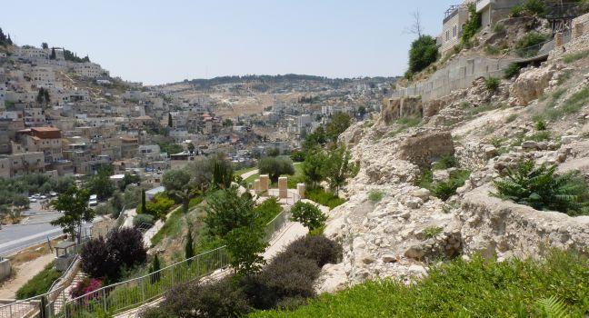
Just south of today's Old City walls, the City of David was the core of Old Testament Jerusalem, built more than four millennia ago on a 15-acre spur over the vital Gihon Spring. It was given its royal Israelite sobriquet 1,000 years later, when the legendary King David conquered the city and made it his capital (II Samuel 5). Begin with the great rooftop observation point above the visitor center. Consider the 15-minute 3D movie, despite its ideological bias; it's a good historical introduction to the site, especially for kids (call ahead for English-language show times). Below the floorboards of the center are the excavated remains of a large building of the 10th century BC, identified by some archaeologists as King David's fortified palace (though others demur). A few flights of steps down from the center is Area G, dominated by a sloping structure of the same period, possibly a support ramp for the "palace" above. The most intriguing artifacts found here were 51 bullae, clay seal impressions no bigger than a fingernail, used for sealing documents or official correspondence. Some were inscribed, in ancient Hebrew, with the names of personages mentioned in the biblical book of Jeremiah. There is strong circumstantial evidence to suggest that the bullae were baked into permanent pottery by the Babylonian burning of Jerusalem in 586 BC.

Take the steps about a third of the way down the hillside: a small sign on the right directs you to Warren's Shaft and the descent to the spring. Charles Warren, a British army engineer, discovered the spacious, sloping access tunnel—note the ancient chisel marks and rough-cut steps—in 1867. The deep vertical shaft that drops into the Gihon Spring may not have been the actual biblical "gutter" or "water-shaft" through which David's warriors penetrated the city 3,000 years ago—it was apparently hewn in a later era—but an alternative access to the spring has kept the biblical story alive. Three centuries later, King Hezekiah of Judah had a horizontal tunnel dug through solid rock to bring the spring water safely into a new inner-city reservoir.

The tunnel—variously called Siloam, Shilo'ach, or Hezekiah's Tunnel—can be waded today. You will need water shoes or sandals, a flashlight (cheap LED ones are on sale at the visitor center), and appropriate clothing: the water is thigh-deep for the first few minutes, and then below the knees for almost the entire length of the tunnel (a 30-minute walk). The visitor center has lockers for your gear. In this very conservative neighborhood, it's advisable to wear covering over swimsuits when walking outside. The wade is not recommended for very small children or for claustrophobes of any age. If you don't fancy getting wet, you can still view the spring, and then continue through the dry Canaanite tunnel to emerge aboveground.

The tunnel ends in the Pool of Siloam, mentioned in the New Testament as the place where a blind man had his sight restored (John 9); the current pool is its Byzantine successor. From the exit, modern wooden steps take you down and over the large flagstones of a 1st-century-BC commercial street to the edge of an ancient pool unearthed in 2004 by city workers repairing a sewage pipe. Archaeologists exposed finely cut steps and two corners of the pool, apparently a large public mikvah, or Jewish ritual bath, for pilgrims who flocked here 2,000 years ago—and arguably the very pool of the Gospel miracle. Hezekiah's original pool remains hidden.

An underground Roman-period drainage ditch is the adventurous route back up the hill. For an additional fee you can continue still farther north through the ditch (bypassing the visitor center), to the Jerusalem Archaeological Park inside the city walls.

There is a shuttle van (NIS 5) from the pool up the steep hill back to the visitor center, but currently not from the dry exit.

Buy Tickets Now

Clos de Gat

Fodor's choice

Winemaker Eyal Rotem puts a premium on quality at this boutique estate winery that produces 100,000 bottles a year. While it's not kosher, the winery prides itself on its ancient and modern Jewish history: it houses a 3,000-year-old-winepress, and during the 1948 war it served as the base for Itzhak Rabin and his Har'el Brigades. Many Clos de Gat wines age beautifully, including the Sycra series, which has garnered international accolades. 

Rte. 44, Israel
02-999–3505
Sights Details
Rate Includes: Tours and tastings NIS 150, Closed Sat. Other days, by appointment only

Coral Beach Nature Reserve

Fodor's choice

Less than 1 km (½ mile) south of Eilat is one of the finest, most densely populated coral reefs on the planet; it's also the world's northernmost reef. Close to the shoreline and zealously guarded by the Israel Nature and Parks Authority, it stretches 1¼ km (¾ mile) and contains more than 100 types of coral and 650 species of fish. In the lagoon, divers and snorkelers take two bridges or a trail marked by buoys to reach the reef wall. Stunning multicolored fish and soft and hard corals are your rich reward. There are hot showers, a snack bar, and snorkel rentals. Kids should be at least five to snorkel.

Dome of the Rock and Haram esh-Sharif (Temple Mount)

Fodor's choice

The magnificent golden Dome of the Rock dominates the vast 35-acre Temple Mount, the area known to Muslims as Haram esh-Sharif (the Noble Sanctuary). At its southern end, immediately in front of you as you enter the area from the Western Wall plaza (the only gate for non-Muslims), is the large, black-domed al-Aqsa Mosque, the third in holiness for Muslims everywhere.

Herod the Great built the Temple Mount in the late 1st century BC, and included on the center of the plaza was the Second Temple, the one Jesus knew.

Jewish tradition identifies the great rock at the summit of the hill—now under the gold dome—as the foundation stone of the world, and the place where Abraham bound and almost sacrificed his son Isaac (Genesis 22). With greater probability, this was where the biblical King David made a repentance offering to the Lord (II Samuel 22), and where his son Solomon built "God's House," the so-called First Temple. The Second Temple stood on the identical spot, but the memory of its precise location was lost after the Roman destruction and the banning of Jews from Jerusalem.

The Haram today is a Muslim preserve, and tradition has it that Muhammad rose to heaven from this spot in Jerusalem to meet God face-to-face, received the teachings of Islam, and returned to Mecca the same night, and the great rock was the very spot from which the Prophet ascended.

The Muslim shrines are closed to non-Muslims to leave the faithful alone to enjoy the wondrous interiors of stained-glass windows, granite columns, green-and-gold mosaics, arabesques, and superb medieval masonry. Even if you can't get inside, the vast plaza is both visually and historically arresting and worth a visit. Take a look at the bright exterior tiles of the Dome of the Rock and the remarkable jigsaws of fitted red, white, and black stone in the 14th- and 15th-century Mamluk buildings that line the western edge of the plaza.

Security check lines to enter the area are often long; it's best to come early. Note that the gate near the Western Wall is for entrance only. You can exit through any of the other eight gates on the site. The Muslim attendants are very strict about modest dress, and prohibit Bibles in the area.

For information about these sites, see the feature "Jerusalem: Keeping the Faith" in this chapter.

Dor Beach

Fodor's choice

Part of a coastal nature reserve, Dor Beach, also known as Tantura Beach, is a dreamy stretch of beige sand. Rocky islets form breakwaters and jetties provide calm seas for happy bathers. Amenities are ample: chair and umbrella rentals, a first-aid station, a restaurant, and changing rooms. The beach, beside Kibbutz Nahsholim, gets crowded on summer weekends and holidays. Amenities: food and drink; lifeguards; parking; showers; toilets. Best for: partiers; swimming; walking.

Off Rte. 4, 30815, Israel
Sights Details
Rate Includes: Nature reserve NIS 37, beach entrance free

Ein Gedi Nature Reserve

Fodor's choice

This beautiful nature reserve has a number of well-marked trails, all of which are off the main entrance. It is home to Nahal David (David's Stream), and the cave at Nahal David is believed to be the place where David hid while Saul hunted him down 3,000 years ago (I Samuel 24:1–22). Walkers can also visit the canyon of Nahal Arugot and the remains of an ancient synagogue and village. Get a map from the admission booth, and plan to spend anywhere from an hour to a day here, depending on your interest in nature and hiking. Reaching Ein Gedi from the north, the first turnoff to the right is the parking lot at the entrance to the reserve.

The clearly marked trail to Nahal David rises past several pools and small waterfalls to the upper waterfall. There are many steps, but it's not too daunting. Allow at least 1¼ hours to include a dip under one of the lower waterfalls. Look out for ibex (wild goats), especially in the afternoon, and for the small, furry hyrax, often seen on tree branches. Leopards here face extinction because of breeding problems and are seldom seen nowadays.

If you're a serious hiker, don't miss the trail that breaks off to the right 50 yards down the return path from the top waterfall. It passes the remains of Byzantine irrigation systems and has breathtaking views of the Dead Sea. The trail doubles back on itself toward the source of Nahal David. Near the top, a short side path climbs to the remains of a 4th century BC Chalcolithic temple, the treasures of which can be seen in Jerusalem's Israel Museum. The main path leads on to the streambed, again turns east, and reaches Dudim Cave, formed by boulders and filled with crystal clear spring water. Swimming in "Lover's Cave" is one of the most refreshing and romantic experiences in Israel. Since this trail involves a considerable climb (and hikers invariably take time to bathe in the "cave"), access to the trail is permitted only up to 3½ hours before closing time.

Although not as lush as Nahal David, the deep canyon of Nahal Arugot is perhaps more spectacular. Enormous boulders and slabs of stone on the opposite cliff face seem poised in midcataclysm. The hour-long hike to the Hidden Waterfall (not too difficult) passes spots where the stream bubbles over rock shelves and shallow pools give relief from the heat. If you're adventurous and have water shoes, you can return through the greenery of the streambed. Experienced hikers can ascend the Tsafit Trail to Mapal Hachalon (translated as "window waterfall"), where there are stunning views over the Dead Sea.

A Jewish community lived in Ein Gedi for more than 1,200 years, beginning in the 7th century BC. In the 3rd century AD, they built a synagogue between Nahal David and Nahal Arugot. Its beautiful mosaic floor includes an inscription in Hebrew and Aramaic invoking the wrath of heaven on troublemakers including "whoever reveals the secret of the town." The secret is believed to refer to a method of cultivating balsam plants, which were used to make the prized perfume for which Ein Gedi was once famous. These famous plants, brought back to the area in the last decade after disappearing hundreds of years ago, can be seen in the botanical garden of the nearby Kibbutz Ein Gedi.

Reservations can be made in advance online or by phone, though you may need a Hebrew speaker to help you.

Ein Kerem

Ein Kerem Fodor's choice

The neighborhood of Ein Kerem still retains much of its old village character. Tree-framed stone houses spill across its hillsides with a pleasing Mediterranean nonchalance. Artists and professionals who have joined the older working-class population over the last 40 or 50 years have marvelously renovated many homes and made an effort to keep most developers at bay. Back alleys provide an off-the-beaten-path feel, and occasionally a serendipitous art or craft studio.

Tradition identifies Ein Kerem as the birthplace of John the Baptist, and its most prominent landmarks are the orange-roofed Church of St. John the Baptist in the heart of the village, the Church of the Visitation up the hillside above the Spring of the Virgin—both Roman Catholic—and the gold-domed Russian church above that along the road to Hadassah Hospital. The neighborhood is served by city Bus 28 from Mount Herzl. There is free underground parking in the neighborhood center. Ein Kerem is less than five minutes from Mount Herzl by bus or taxi, and about 15 minutes by taxi from Downtown.

Buy Tickets Now

First Station

Fodor's choice

This was once the terminus of the old Jaffa–Jerusalem railroad, inaugurated in 1892. It survived two world wars and two regime changes until the suspension of rail service in 1998. Despite being boarded up, the handsome building's limestone facade, gabled roof, and arched doorways stood as a reminder of its glory days. A creative renovation has won accolades, especially from Jerusalemites. In a city not known for its contemporary attractions, First Station made a splash with its cafés and restaurants, shaded crafts stalls, and play equipment for the kids (and sometimes balloon artists or puppeteers). Evening performances and other cultural events have become popular, especially in the warmer months. The compound is open on Saturday, but only really comes alive in the evening.

Flam Winery

Fodor's choice

Family-owned, this well-regarded winery sources grapes from the Judean Hills and the Upper Galilee. Many of its bottles, including the Bordeaux blend called The Noble, have garnered international praise for their complexity. Wine-and-cheese tastings are held by appointment only at an elegantly rustic communal table indoors or outside on a wooden deck overlooking the vineyards that are surrounded by pine forests.

German Colony

Fodor's choice

Although it runs along a single boulevard, "The Colony" packs in history (with explanatory placards), interesting architecture, great restaurants, and wonderful spots for people-watching. Ben Gurion Boulevard was the heart of a late-19th-century colony established by the German Templer religious reform movement. Along either side are robust, two-story, chiseled limestone houses with red-tile roofs. Many bear German names, dates from the 1800s, biblical inscriptions on the lintels, and old wooden shutters framing narrow windows.

Neglected for years, the German Colony is now one of the city's loveliest (and flattest) strolls. It's best to start your exploration around Yaffo (Jaffa) Street so that you're walking toward the stunning Baha'i Gardens. Along the way you can have a meal or cup of coffee, explore the shops in the City Centre Mall, and learn about the history of the Templers. Any time of day is pleasant, but evening, when the cafés and restaurants are brimming with people, is best.

The Templers' colony in Haifa was one of seven in the Holy Land. The early settlers formed a self-sufficient community; by 1883, they had built nearly 100 houses and filled them with as many families. Industrious workers, they introduced the horse-drawn wagon—unknown before their arrival—to Haifa. They also built with their own funds a pilgrimage road from Haifa to Nazareth. The Germans' labors gave rise to modern workshops and warehouses, and it was under their influence that Haifa began to resemble a modern city, with well-laid-out streets, gardens, and attractive homes.

Haifa's importance to Germany was highlighted in 1898, when Kaiser Wilhelm II sailed into the bay on the first official visit to the Holy Land by a German emperor in more than 600 years. In the 1930s, many Templers began identifying with German nationalism and the Nazi party. During World War II, the British deported them as nationals of an enemy country.

Haas Promenade

Fodor's choice

Get your bearings in Jerusalem by taking in the panorama from the Haas Promenade, an attractive 1-km (½-mile) promenade along one of the city's highest ridges. Hidden behind a grove of trees to the east (your right as you pan the view) is a turreted limestone building, the residence of the British High Commissioner for Palestine in the 1930s and 1940s. In Hebrew, the whole ridge is known as Armon Hanatziv, the Commissioner's Palace. In 1949, the building became the headquarters of the U.N. Truce Supervision Organization (UNTSO), charged with monitoring the armistice line that divided the city. It remained a neutral enclave between Israeli West Jerusalem and Jordanian-controlled East Jerusalem until the reunification of the city in the Six-Day War of 1967. You can reach the promenade by car from Hebron Road—consult a map, and look for signs to East Talpiot and the Haas Promenade—by Bus 78 from the Central Bus Station, Downtown, and the First Station; Bus 12 from Hadassah Ein Kerem and Malkha Mall; or by cab. If the traffic flows well, it's a 10-minute drive from Downtown, five minutes from the German Colony. There are restrooms just off the sidewalk at the city end of the ridge, before the promenade dips down into the valley.

Hermon Stream (Banias) Nature Reserve

Fodor's choice

One of the most stunning parts of Israel, this reserve contains gushing waterfalls, dense foliage along riverbanks, and the remains of a temple dedicated to the god Pan. There are two entrances, each with a parking lot: the sign for the first reads "Banias Waterfall," and the other is 1 km (½ mile) farther along the same road and is marked "Banias."

The Banias Spring emerges at the foot of mostly limestone Mount Hermon, just where it meets the basalt layers of the Golan Heights. The most popular short route in the reserve is up to the Banias Cave, via the path that crosses the spring. Excavations have revealed five niches hewed out of the rock to the right of the cave; these are what remain of Hellenistic and Roman temples, depicted in interesting artist renderings. Three of the niches bear inscriptions in Greek, mentioning Pan, the lover of tunes; Echo, the mountain nymph; and Galerius, one of Pan's priests. All early references to the cave identify it as the source of the spring, but earthquakes over the years have changed the landscape, and the water now emerges at the foot of the cave rather than from within it.

The reserve offers three interconnected hiking trails—ask for the English-language trail map and advice at the cashier's booth. One, which passes a Crusader gate, walls, and moat, takes about 45 minutes. The second, also about 45 minutes, explores the magnificent 1,613-square-foot palace complex dating to the 1st century AD and the reign of Herod's grandson, Agrippa II, on top of which are the ruins of what is thought to have been the marketplace of the day: a string of single chambers along a well-preserved section of wall might well have been shops. The third is a 90-minute trail leading past the Officers' Pool, built by the Syrians, and a water-operated flour mill, to the thundering 33-meter-high Banias Waterfall. The trails are spiced with the pungent aroma of mint and figs, and studded with blackberry bushes. If time is short, you may prefer to take a brief walk to the falls, return to your car, then drive on to the second entrance to see the caves and the spring where the Hermon Stream originates. The cost of admission covers entry to both sites.

If you're ready for a real hiking challenge and can have a car waiting at the other end, a long, very steep trail leads from the parking lot at the Banias Nature Reserve through the oak and thorny broom forest up to Nimrod's Fortress, a 40- to 60-minute climb.

Herodian Quarter/Wohl Archaeological Museum

Fodor's choice

Excavations in the 1970s exposed the Jewish Quarter's most visually interesting site: the remains of sumptuous mansions from the late Second Temple period. Preserved in the basement of a modern Jewish seminary—but entered separately—the geometrically patterned mosaic floors, still-vibrant frescoes, and costly glassware and ceramics provide a peek into the life of the wealthy in the days of Herod and Jesus. Several small plastered cisterns, with broad steps descending into them, have been identified as private mikvahs (Jewish ritual baths); holograms depict their use. Large stone water jars are just like those described in the New Testament story of the wedding at Cana (John 2). Rare stone tables resemble the dining-room furniture depicted in Roman stone reliefs found in Europe.

On the last of the site's three distinct levels is a mansion with an estimated original floor area of some 6,000 square feet. None of the upper stories has survived, but the fine, fashionable stucco work and the quality of the artifacts found here indicate an exceptional standard of living, leading some scholars to suggest this may have been the long-sought palace of the high priest. The charred ceiling beams and scorched mosaic floor and fresco at the southern end of the reception hall bear witness to the Roman torching of the neighborhood in the late summer of AD 70, exactly one month after the Temple itself had been destroyed. Allow about 45 minutes to explore the site.

Hilton Beach

Fodor's choice

In front of the hotel of the same name, Hilton Beach is very popular, especially with enthusiastic matkot players. The northern end of the beach is a gay-friendly area known as Gay Beach, which can get packed on sunny summer afternoons, especially during Tel Aviv Pride. Here you'll also find Dog Beach, which got its name because pampered pooches are let off their leashes to play. There is no car access, so walk or bike down the promenade to reach this stretch of sand. Amenities: food and drink; lifeguards; showers; toilets; water sports. Best for: surfing; swimming; walking; windsurfing.

Hisham's Palace

Fodor's choice

Known as Khirbet al-Mafjar in Arabic, this restored palace has exquisite stonework and a spectacular mosaic floor. Hisham was a scion of the Umayyad Islamic dynasty, which built the Dome of the Rock and al-Aqsa Mosque in Jerusalem. Although the palace was severely damaged by the great earthquake of 749 AD, the surviving mosaics and stone and plaster reliefs attest to its splendor. A huge canopy, added as part of a Japanese-funded restoration effort, provides shade as you tread on catwalks above the stonework, including the renowned "Tree of Life" mosaic. Fragments of ornate stucco reliefs are still visible on some of the walls. The site is about 4 km (2.5 miles) north of central Jericho, and the restaurant just beside it serves tasty Palestinian salads and meats, along with fresh juices and coffee.

Hospitaller Fortress (Knights' Halls)

Fodor's choice

This remarkable 12th-century Crusader fortress was once known as the Crypt of St. John—before excavation, it was erroneously thought to have been an underground chamber. The dimensions of the colossal pillars that support the roof (girded with metal bands for extra strength) make this one of Israel's most monumental examples of Crusader architecture. It's also one of the oldest Gothic structures in the world. In the right-hand corner opposite the entrance is a fleur-de-lis carved in stone, the crest of the French house of Bourbon, which has led some scholars to suggest that this was the chamber in which Louis VII convened the knights of the realm.

Just outside this room is an entrance to an extremely narrow subterranean passageway. Cut from stone, this was a secret tunnel that the Crusaders probably used to reach the harbor when besieged by Muslim forces. (Those who are claustrophobic can take an alternate route, which goes back to the entrance of the Turkish bathhouse and continues from there.) Emerge in the cavernous vaulted halls of the fortress guard post, with a 13th-century marble Crusader tombstone at the exit.

Here, a series of six barrel-vaulted rooms known as the Knights' Halls has been discovered. Arrows point the way through vast rooms filled with ongoing reconstruction work, huge marble columns, and archaeological finds. Above this part of the Crusader city stands the Ottoman citadel, which you can glimpse from the courtyard. Built by Dahr el-Omar in the 18th century on the rubble-filled Crusader ruins, the citadel was the highest structure in Akko.

The different factions within Akko's walls probably sowed the seeds of the Crusaders' downfall here. By the mid-13th century, open fighting had broken out between the Venetians and Genoese. When the Mamluks attacked with a vengeance in 1291, the Crusaders' resistance crumbled, and the city's devastation was complete. It remained a subdued place for centuries, and even today Akko retains a medieval cast.